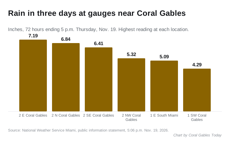
Gauges near Coral Gables recorded up to 7.19 inches of rain in three days. The flood watch now runs to 7 a.m. Friday, with drier weather forecast for the weekend.
Coral Gables is under a flood watch until 7 a.m. Friday. The National Weather Service in Miami extended it Thursday afternoon, from 7 p.m. Thursday, because standing water remained in parts of the east coast metro areas and more rain could make flooding worse.
Gauges around Coral Gables have recorded 4 to 7 inches of rain since Monday evening. The weather service expects the main threat of heavy rain to move north by late Friday morning, letting the watch expire, with drier weather this weekend, according to its forecast discussion.
Overview
Updated Nov. 19: the flood watch was extended to 7 a.m. Friday. Gauges near Coral Gables recorded up to 7.19 inches in the 72 hours to 5 p.m. Thursday. Thursday’s flood advisories covered northern Miami-Dade, not Coral Gables. The forecast below is the latest.
- What: a flood watch for all of Southeast Florida, including metropolitan and coastal Miami-Dade County
- Until: 7 a.m. Friday, Nov. 20
- Rain so far: 4.29 to 7.19 inches at gauges around Coral Gables over three days
- Rain still possible: 1 to 2 inches where showers linger Thursday night, with isolated 3 to 5 inches, the watch says
- Main risk: flooding in low-lying streets and areas with poor drainage
- Also: dangerous rip currents at the coastal Miami-Dade beaches until 7 p.m. Friday
A watch means flooding is possible. If flooding is happening or about to, the weather service issues a flood advisory or a flash flood warning.
Thursday: watch extended to Friday morning
The weather service extended the flood watch at 3:18 p.m. Thursday. It said 3 to 5 inches of rain had fallen widely along the east coast of South Florida over several days, with pockets of 8 to 15 inches. Those wetter areas are the most likely to flood again.
The weather service issued three flood advisories for northern Miami-Dade County Thursday morning, the last ending at 11:45 a.m. They listed Hialeah, Miami Lakes, Hialeah Gardens, Medley, Palm Springs North and Country Club. Radar showed 2 to 3 inches had fallen there. Coral Gables was not named in Thursday’s advisories, according to the weather service alerts for Miami-Dade.
The rain also delayed work in the city. A Miami-Dade Water and Sewer Department water service renewal near 5965 Ponce de Leon Blvd., set for 8 p.m. Wednesday, was postponed because of the weather, the city said. The southbound lane closure near Sagua Avenue did not happen. The city said it will post a new date once one is set.
Rain totals around Coral Gables
The weather service’s 72-hour rainfall report, for the period ending at 5 p.m. Thursday, lists these readings at gauges it places near the city:
| Gauge location, as the weather service names it | Rain in 72 hours |
|---|---|
| 2 miles east of Coral Gables | 7.19 inches |
| 2 miles north of Coral Gables | 6.84 inches |
| 2 miles southeast of Coral Gables | 6.41 inches |
| 2 miles northwest of Coral Gables | 5.32 inches |
| 1 mile east of South Miami | 5.09 inches |
| 1 mile southwest of Coral Gables | 4.29 inches |
Where the report lists several gauges at one location, the table gives the highest. The largest total in Miami-Dade County was 9.86 inches, 1 mile southwest of Aventura.
Miami International Airport, about five miles north of Coral Gables, had 0.15 inch Thursday through 4 p.m. That took November’s total to 9.39 inches, against a normal of 2.44 inches for the month so far, according to the daily climate report for Miami.
Wednesday: flood advisories over Coral Gables
The weather service issued its first flood advisory for northern Miami-Dade County at 9:17 a.m. Wednesday. It listed Coral Gables, South Miami, the University of Miami, Coral Terrace, West Miami and Glenvar Heights among the places that could flood. Radar showed 1 to 2 inches had already fallen.
The advisories were extended through the day:
| Issued | In force until | Rain already fallen, per radar |
|---|---|---|
| 9:17 a.m. | 11:15 a.m. | 1 to 2 inches |
| 11:08 a.m. | 12:45 p.m. | 1 to 2 inches |
| 12:35 p.m. | 1:45 p.m. | 2 to 3 inches |
| 1:47 p.m. | 3:45 p.m. | 2 to 3 inches |
Each advisory warned of minor flooding in low-lying and poorly drained areas. The 11:08 a.m. update said an upgrade to a flash flood warning could be needed.
That upgrade came farther south. At 2:20 p.m. the weather service issued a flash flood warning for central Miami-Dade until 4:15 p.m. Radar showed 3 to 5 inches had fallen there. The places it named included Palmetto Bay, about six miles south of Coral Gables, along with Cutler Bay and Homestead. Coral Gables was not in that warning.
Broward County had it worst. In its forecast discussion Wednesday afternoon, the weather service said radar estimated 8 to 15 inches had fallen over 12 hours around Davie, Hollywood, Fort Lauderdale, Dania Beach and Plantation. It said roads there were impassable and flood water had entered homes.
At 2:10 p.m. the weather service added a wind advisory for metropolitan Miami-Dade until 1 a.m. Thursday. It forecast east winds of 25 to 30 mph with gusts up to 45 mph, enough to bring down tree limbs and cause a few power outages.
Why it keeps raining
A weak low-pressure system is sitting in the Gulf. A stalled front linked to it lies across central Florida, and high pressure over the East Coast is pushing strong east winds onshore.
In its forecast discussion Tuesday, the weather service said that setup can send “repeated rounds of relentless heavy rainfall” onto the immediate east coast. Forecasters said:
- widespread totals of 2 to 4 inches are most likely along the east coast through Friday
- a reasonable worst case is 6 to 10 inches, with a 10% chance of more
- the heaviest totals are forecast for coastal Palm Beach and Broward counties, closer to the front
- exactly where the heaviest rain falls is hard to predict, and “impactful flash flooding will be possible anywhere along the east coast”
The Weather Prediction Center has the region at a slight risk, level 2 of 4, of excessive rainfall Tuesday and Wednesday. The weather service said the low could linger in the Gulf through the end of the week, so heavy rain may continue into Friday.
Wednesday at the airport
Miami International Airport, about five miles north of Coral Gables, had 1.76 inches of rain Wednesday through 4 p.m. The normal for the date is 0.12 inch. The airport also recorded a gust of 50 mph.
That brings November’s total to 9.09 inches, nearly four times the 2.34 inches normal for the month so far, according to the weather service’s daily climate report for Miami. On Tuesday afternoon the total stood at 7.08 inches.
The airport had 1.57 inches on Nov. 1 alone, during the flood watch at the start of the month. The year is still dry. Miami has had 50.06 inches since Jan. 1, which is 13.72 inches below normal.
The forecast for Coral Gables
The weather service forecast for Coral Gables issued Thursday afternoon gives:
| When | Chance of rain | Details |
|---|---|---|
| Thursday night | 20% | Showers possible before midnight, partly cloudy, low around 71 |
| Friday | 20% | Mostly sunny, showers possible after 3 p.m., high near 82 |
| Friday night | Under 20% | Partly cloudy, low around 70 |
| Saturday | 30% | Mostly sunny, showers possible after 1 p.m., high near 83 |
| Saturday night | 30% | Showers possible before 7 p.m., mostly clear, low around 69 |
The weather service said the widespread flood threat should ease by Friday afternoon, with drying this weekend. Rough marine and beach conditions are expected to last into the weekend along the Atlantic coast.
A mostly sunny Saturday morning is forecast as ESPN’s College GameDay broadcasts from the University of Miami campus from 9 a.m. to noon.
Storms Tuesday afternoon
At 4:54 p.m. Tuesday, the weather service issued a special weather statement for a strong storm near Key Biscayne moving west at 25 mph. It warned of gusts of 45 to 50 mph that could knock down tree limbs, and listed Coral Gables and the University of Miami among the places in its path.
A special marine warning for Biscayne Bay followed at 5:45 p.m., for storms that could produce waterspouts. It ran until 7:15 p.m.
On the water, forecasters said sustained winds of 20 to 30 knots, with gusts to 35 knots, were developing over local waters Tuesday, with Atlantic seas climbing to 10 to 12 feet. A rip current statement for the coastal Miami-Dade beaches has been extended until 7 p.m. Friday.
What it means for you
- If your street floods in heavy rain, move cars to higher ground before the next round of storms.
- Never drive through a flooded road or around a barricade. The weather service’s Turn Around Don’t Drown page says 12 inches of rushing water can carry away most cars.
- Gusty storms can blow around unsecured objects, so bring in or tie down patio furniture and empty trash cans.
- Watch for a flood advisory or a flash flood warning. Either means flooding is happening or about to. The weather service said the watch could lead to warnings if repeated downpours set up.
- On Biscayne Bay, the weather service tells boaters to move to safe harbor when a special marine warning is in force.
- At the Atlantic beaches, swim near a lifeguard while the rip current statement lasts.
If the storms knock out power, our power outages page lists who to call. For a non-emergency question, call the city at 305-446-6800. In an emergency, call 911.
Have your say